

About Me
Hey there. I'm Jonathan — Founder & Principal at Vector Scope AI, delivering spatial intelligence solutions for government and enterprise. I build the lakehouse layer for ArcGIS: versioned GeoParquet and Iceberg, validation APIs, and collaborative editing so agencies keep analytics-ready data.
Previously at DRT Strategies (CDC), National Grid, U.S. Census Bureau, and Booz Allen Hamilton.
Core Skills
Apache Iceberg
GeoParquet
GeoAI
Spatial Data Engineering
Python
JavaScript
SQL
REST APIs
Validation APIs
ETL Automation
Cloud-Native Architecture
Docker
Jenkins
GitLab
CI/CD
FedRAMP/FISMA
Azure
AWS
ArcGIS Enterprise
PostgreSQL/PostGIS
Agile/Scrum
Technical Project Management
Featured work
Download Resume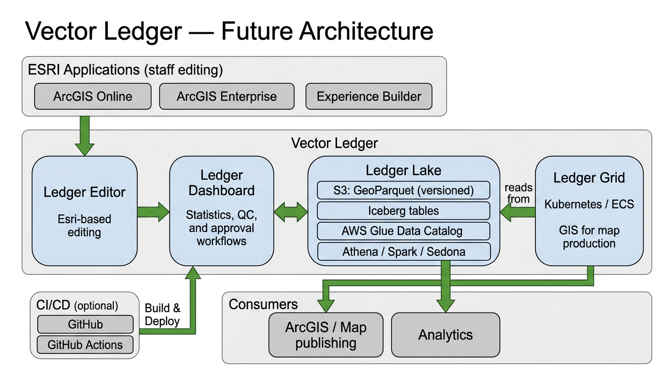
Vector Ledger
Apache Iceberg, GeoParquet, ArcGIS, Validation API
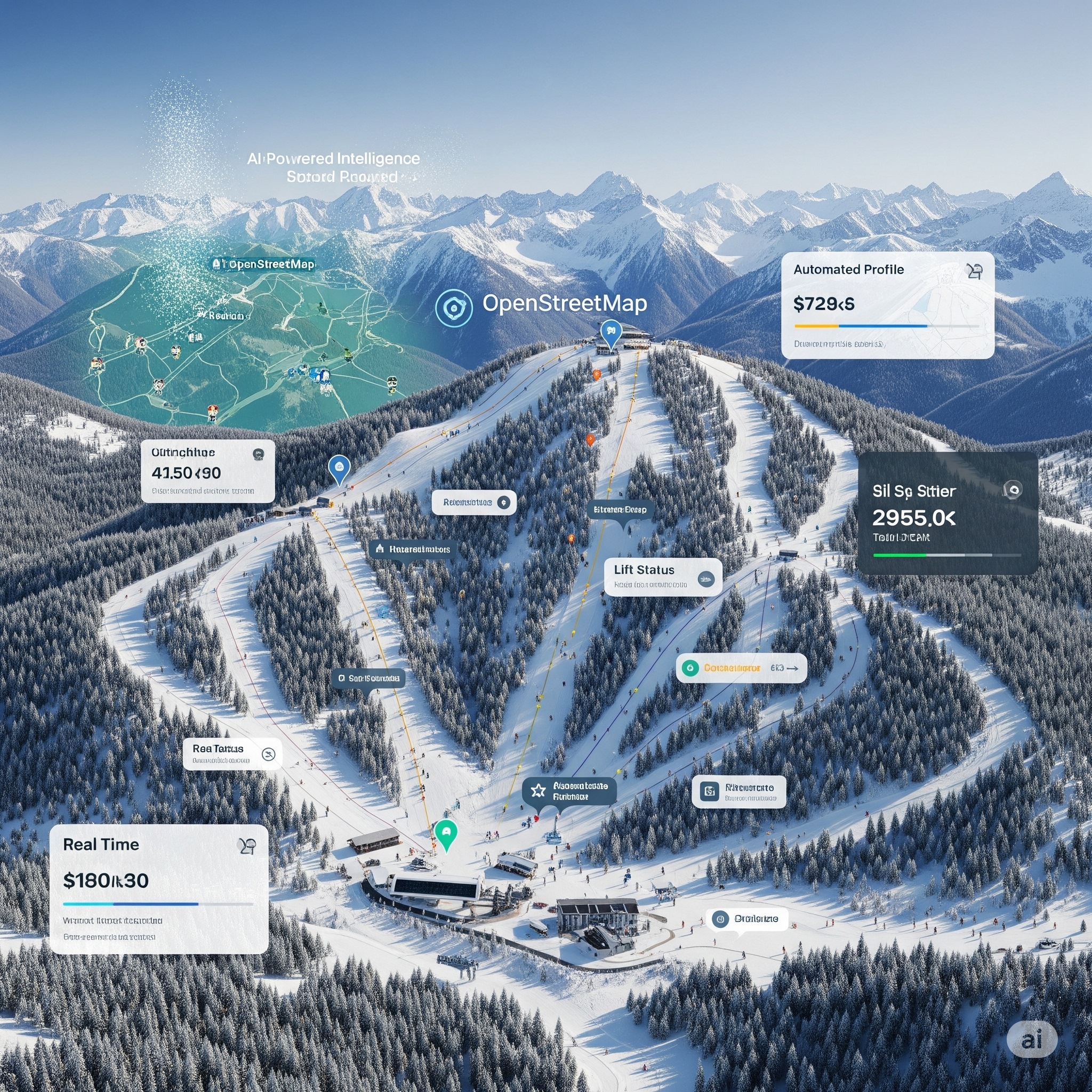
Global Ski Atlas
Python, JavaScript, Web GIS, ETL
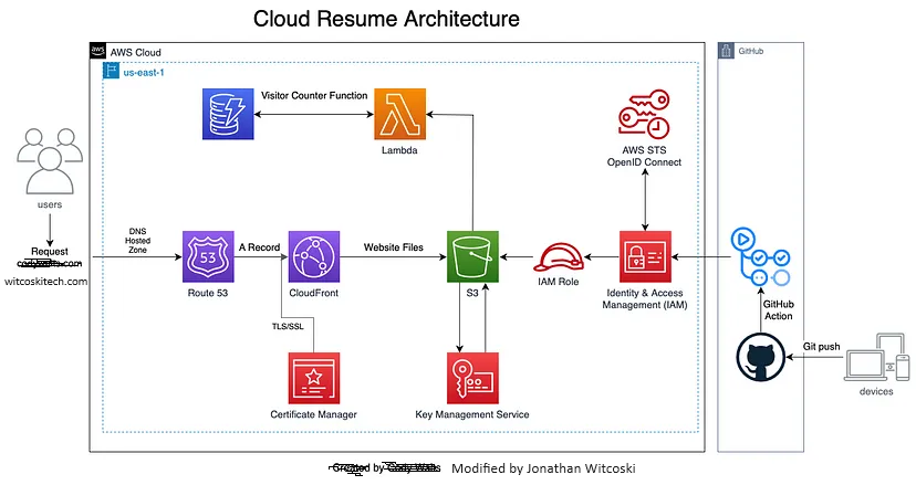
Cloud Resume Challenge
AWS, CI/CD, IaC, REST APIs
Experience
Founder & GIS Architect | Vector Scope AI LLC
2025 – Present · Remote
- •Building Vector Ledger—the lakehouse layer for ArcGIS: collaborative map updates for agencies with versioned GeoParquet and Apache Iceberg
- •Bridging ArcGIS Online/Enterprise with Spark/Sedona/Iceberg data lakes so staff edit via Esri web apps and output stays portable and analytics-ready
- •Designing Ledger Editor, Dashboard, Lake (GeoParquet storage), and Ledger Grid (Kubernetes GIS) with changelog history and validation APIs for agency pilots
- •Implementing rules engine and topology validation (e.g., pipe sizing) stored in lakehouse Parquet—enforce edit-time constraints without separate databases
- •Running Global Ski Atlas as live demo (3000+ resorts, web editor, public atlas) to prove the platform for boundaries and program areas
- •Pursuing Esri Startup Program and pilot engagements for agencies needing collaborative editing and GeoParquet for ArcGIS
Senior Geographer & GIS Solutions Developer | DRT Strategies (CDC)
2022 – Present · Remote
- •Lead design of GIS and AI solutions supporting CDC public health surveillance programs nationwide
- •Architect enterprise geospatial software improving data timeliness by 60% for epidemiologists
- •Develop interactive web mapping applications and dashboards using ArcGIS Enterprise, React, and Power BI
- •Build spatial databases and ETL workflows processing 10M+ records monthly with 99.9% reliability
- •Provide technical leadership across CDC divisions on enterprise GIS and automation best practices
GIS Data Engineer & Scrum Master | Saicon (National Grid)
2021 – 2022 · Remote
- •Designed large-scale GIS migration for utility datasets affecting 1M+ customers to cloud platforms
- •Led cross-functional Agile teams delivering migration milestones with 98%+ data quality
- •Developed spatial ETL workflows using Python, SQL, and Azure services
- •Configured high-availability ArcGIS Enterprise with 99.95% uptime and zero service interruptions
Senior Geographer & GIS Application Developer | U.S. Census Bureau
2016 – 2021 · Suitland, MD
- •Developed mission-critical GIS tools using Python and ArcGIS APIs
- •Created automated workflows reducing manual processing by 70%
- •Supported disaster response with rapid geographic updates during hurricanes
GIS Systems Administrator & Software Engineer | C2 Solutions Group Inc.
2014 – 2016 · Reston, VA
- •Designed and secured enterprise GIS solutions for federal clients
- •Administered ArcGIS Server/Portal deployments supporting hundreds of concurrent users
- •Developed secure web mapping applications following DevSecOps and OWASP standards
- •Maintained 99.9% platform availability in mission-critical environments
Geospatial Analyst & Solutions Developer | Booz Allen Hamilton (DHS/FEMA)
2009 – 2014 · Philadelphia, PA & Arlington, VA
- •Built GIS solutions for DHS and FEMA emergency response operations
- •Developed spatial analysis workflows supporting real-time disaster response
- •Created mapping applications improving operational decision support during major disasters
Education
2007
Master of Science in Geography
University of Tennessee, Knoxville
—
Bachelor of Arts, Geography and Anthropology
Penn State University — Minor in GIS
2021
AWS Certified Cloud Practitioner
Amazon Web Services
Contact