

About Me
I'm Jonathan, a GIS engineer building toward Solutions Architect roles, with 15+ years designing enterprise geospatial systems for CDC, utilities, and federal clients. I connect ArcGIS, cloud platforms, and spatial data pipelines so maps and services scale.
Currently Geospatial Engineer at INCATech. Previously DRT Strategies (CDC), National Grid, U.S. Census Bureau, C2 Solutions, and Booz Allen Hamilton (FEMA/DHS). Studying for AWS Solutions Architect – Associate; also shipping tools at Vector Scope AI.
Core Skills
AWS
ArcGIS Enterprise
Python
PostgreSQL/PostGIS
System Design
REST APIs
JavaScript / React
ETL Automation
GeoParquet / PMTiles
CI/CD
Featured work
Download Resume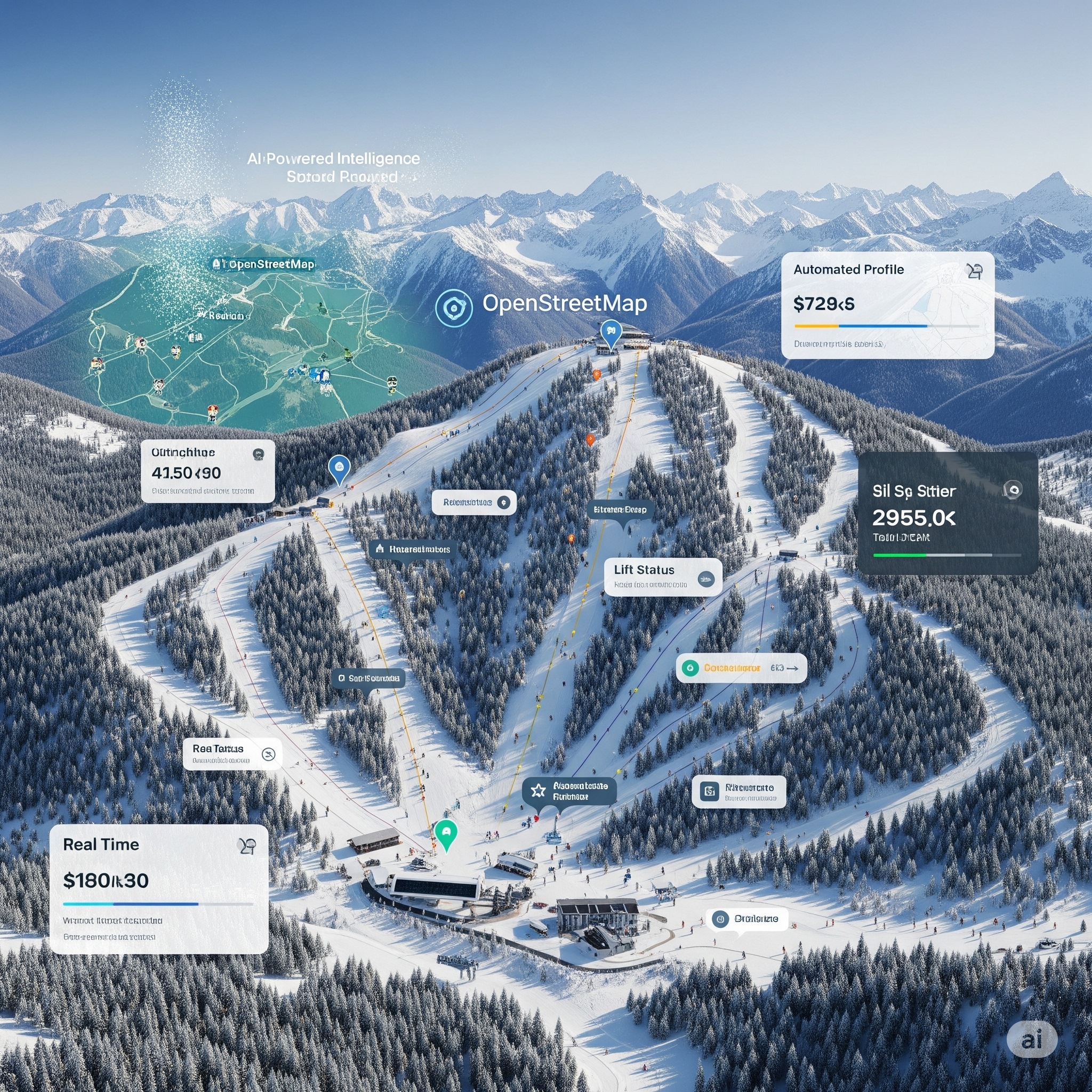
Global Ski Atlas
MapTiler, JavaScript, Python, ETL, Web GIS
Why it matters: Makes 3,000+ ski areas searchable on one live map, kept current by automated Python ETL instead of hand-edited data.
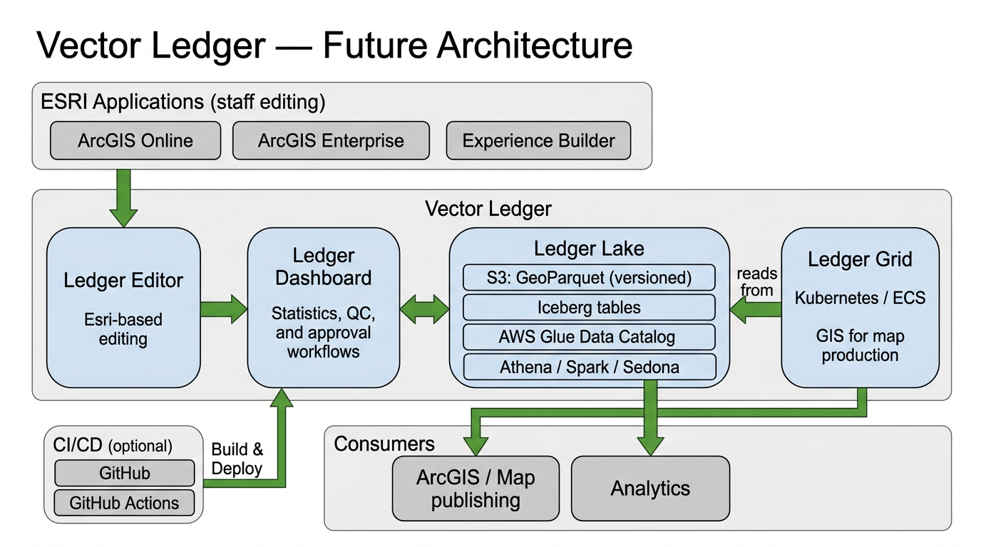
Vector Ledger
ArcGIS, Python, REST APIs, SQL Server
Why it matters: Bridges ArcGIS editing with lakehouse patterns (Iceberg, GeoParquet) so map updates are validated, versioned, and queryable.
Admin Boundary Tool
MapTiler, GeoJSON, Natural Earth, Web GIS
Why it matters: Turns a common cartography need into a reusable boundary workflow instead of manually clipping polygons every time.

Map Agent Arena
Mapbox GL JS, MapTiler SDK, Agent eval, Rubix
Why it matters: Compare agent map skill packs across vendors without hosting eval tooling on the personal homepage.
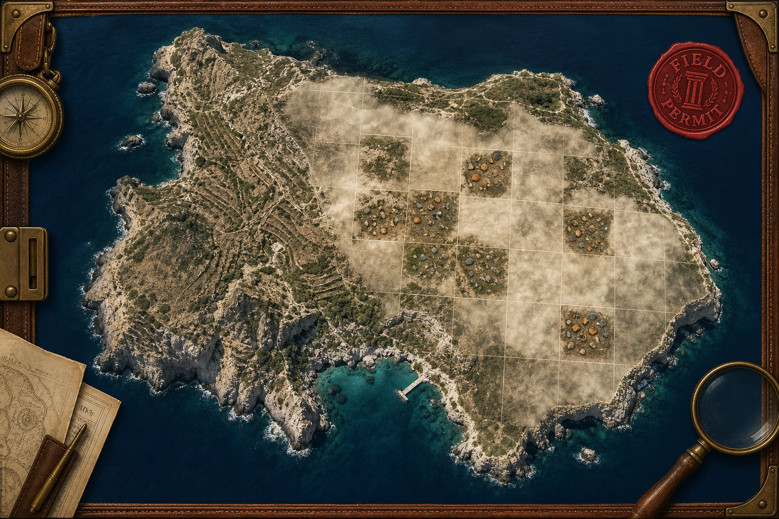
Raiders of Antikythera
MapTiler SDK, PMTiles, GeoJSON, Game design
Why it matters: Proves serious geospatial data can power engaging experiences — real survey tracts, fog-of-war, and chapter-driven discovery.
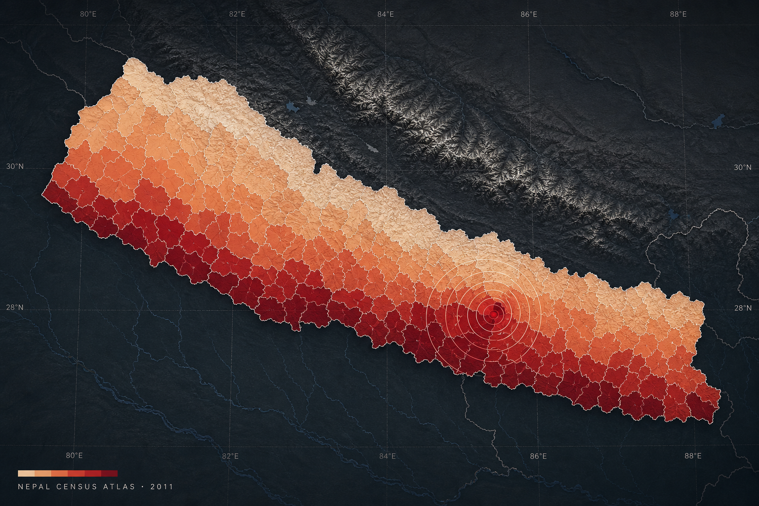
Nepal Census Atlas 2011
Choropleth, GADM, Code for Nepal, Narrative cartography
Why it matters: Turns imperfect public census data into geographically trustworthy chapters so a reader understands a place, not just a color ramp.
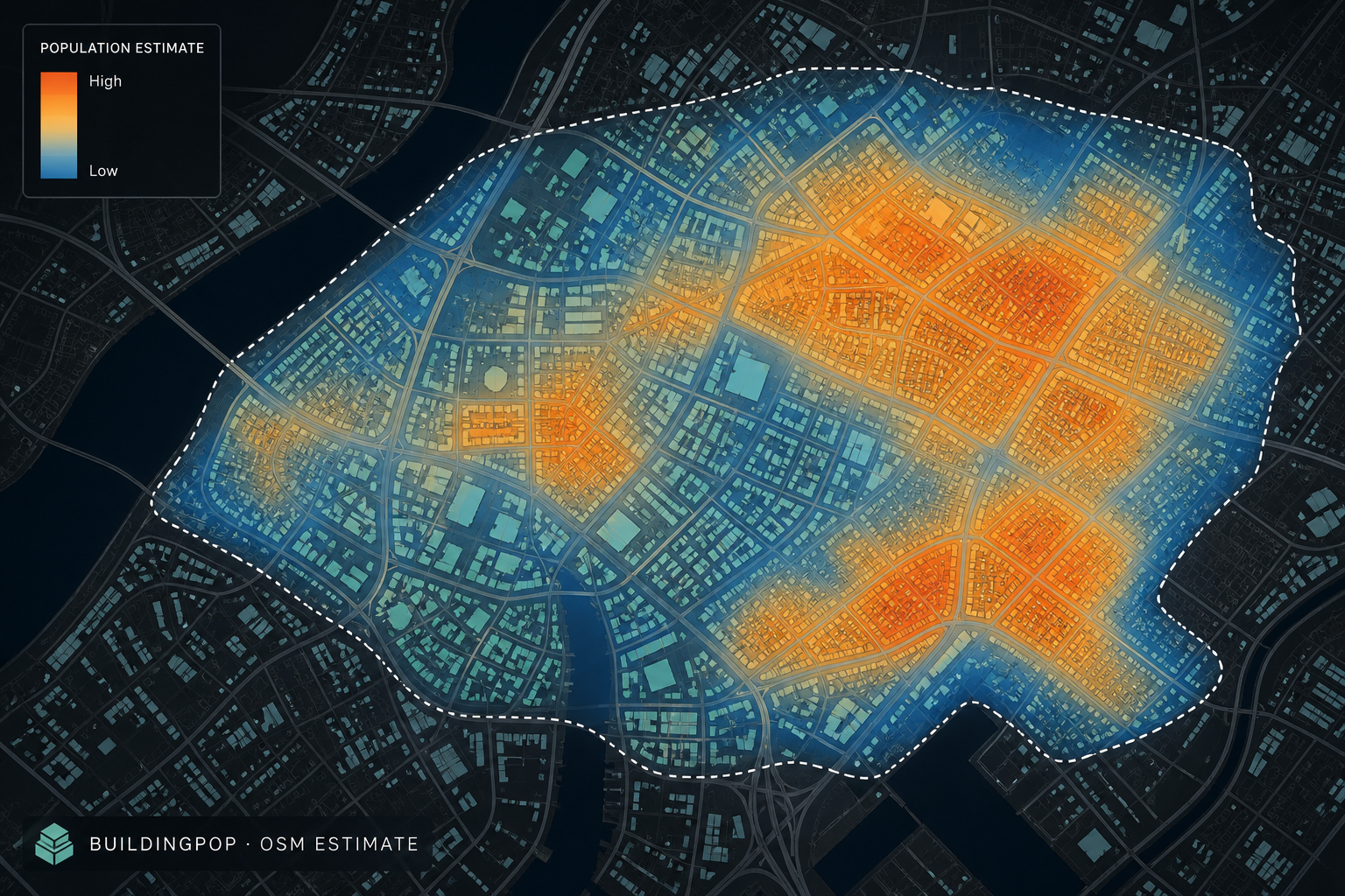
BuildingPop (OSM)
OpenStreetMap, Overpass, Leaflet, WorldPop, GHS-POP
Why it matters: Shows how mapped building footprints become a transparent, adjustable population estimate instead of a black-box density layer.
Platform labs
Mapping and cloud playgrounds
Same hub pattern for each stack — why I use it, what I've built, and what's coming next.
Experience
Geospatial Engineer | INCATech
2026 – Present · Northern Virginia
- •Design, build, and maintain enterprise geodatabases and geospatial workflows with ArcGIS Enterprise, Online, and Desktop for IC and USPIS missions
- •Automate spatial analysis, data validation, and ETL with Python and SQL across Oracle, SQL Server, and PostgreSQL
- •Produce web maps and visualizations, and support GIS users with troubleshooting, migrations, and documentation
Founder | Vector Scope AI LLC
2025 – Present · Remote
- •Build ArcGIS-connected web tools and Python pipelines for map editing, validation, and data extraction
- •Ship Global Ski Atlas (3,000+ ski areas) as a live MapTiler web map with automated ETL
Geographer | DRT Strategies (CDC)
2022 – 2026 · Remote
- •Develop web mapping applications and dashboards with ArcGIS Enterprise, JavaScript, React, and Power BI for CDC surveillance programs
- •Use R and Python to build PMTiles and GeoParquet datasets that feed those dashboards and web maps
- •Build SQL Server and PostgreSQL/PostGIS databases and Python/SQL ETL pipelines for recurring geospatial updates
GIS Data Engineer & Scrum Master | Saicon (National Grid)
2021 – 2022 · Remote
- •Migrated large utility GIS datasets to cloud-hosted ArcGIS Enterprise using Python and SQL
- •Led Agile delivery of migration milestones and spatial data quality checks
Geographer | U.S. Census Bureau
2016 – 2021 · Suitland, MD
- •Developed Python tools and ArcGIS API workflows for census geography production
- •Automated spatial processing workflows across large national datasets
GIS Systems Administrator & Software Engineer | C2 Solutions Group Inc.
2014 – 2016 · Reston, VA
- •Administered ArcGIS Server and Portal deployments backed by SQL Server for federal clients
- •Built secure web mapping applications used by hundreds of concurrent users
Geospatial Analyst | Booz Allen Hamilton (DHS/FEMA)
2009 – 2014 · Philadelphia, PA & Arlington, VA
- •Built maps, spatial analysis workflows, and web GIS tools for FEMA and DHS disaster response
- •Supported situational awareness and decision-making during major disaster operations
Education
2007
Master of Science in Geography
University of Tennessee, Knoxville — thesis & archive2004
Bachelor of Arts, Geography and Anthropology
Penn State University — Minor in GIS
2021
AWS Certified Cloud Practitioner
Amazon Web Services
2026
AWS Solutions Architect – Associate (SAA-C03)
In progress — see study planContact